The Nahal David Stream Accessible Trail
Walk by the the riverbank David
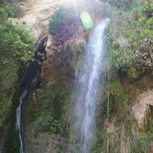
The NPA has created an accessible trail by the Nahal David Stream, allowing people with disabilities to view the waterfall and the lower pool of Nahal David. Nature Conservation Week will mark a project to restore the water to the Ein Gedi Spring slope and to restore the flora in this unique desert oasis by the Dead Sea.
Main Points of Interest:
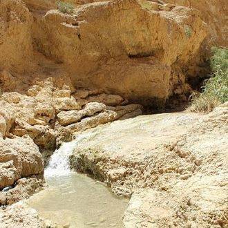
A tour of the desert stream that flows year-round
Discover the reserve’s special fauna
Discover the rare plants reintroduced to the reserve
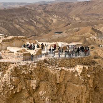
Observation Point
An accessible observation deck overlooking the lower waterfall
NPA Activities to Improve the Service to Visitors and to Conserve the Site
The NPA is restoring Ein Gedi’s plant life and eliminating invasive species. Following the water treaty between the NPA and Kibbutz Ein Gedi, the NPA is reintroducing water to nature, as well as acting to incorporate abandoned terraces in the reserve. The NPA has prepared a 400-meter accessible path.
How to Get There
To get to the Nahal David Stream, take the Dead Sea Highway (90). Turn off between the 244 and 245 marks, 2 km north of Kibbutz Ein Gedi.
Background
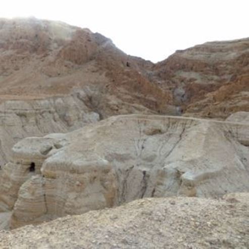
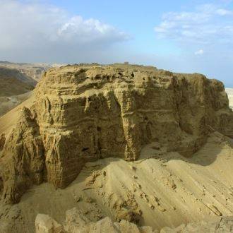
The Ein Gedi Nature Reserve is a magical oasis, and its springs flow to the lowest place on Earth. The reserve, which covers 27,000 dunam, has four springs: the David Spring in Nahal David, Arugot Spring in Nahal Arugot, and the Shulamit and Ein Gedi springs from the slopes between the streams. After decades of drought, the waters of Ein Gedi are finally flowing through their natural channel.
The reserve is a haven for unique flora and fauna, and the International Union for Conservation of Nature (IUCN) includes it in its list of national parks and nature reserves of global value.
The Trail
The Accessible Trail
The trail sets out from the ticket office, along a paved walkway, passing between rare, established trees and vegetation that were reintroduced to the oasis. To the side of the path, under the large Acacia trees, there are benches to rest on and to watch the rock hyrax climbing the Acacias and Salvadora, chewing their leaves with their sharp teeth while they observe what is happening around them. The hyraxes are accustomed to people, and only when they sense danger do they quickly scurry away. The ibex too, have learned that they won’t be harmed in the reserve, and they allow visitors to approach them.
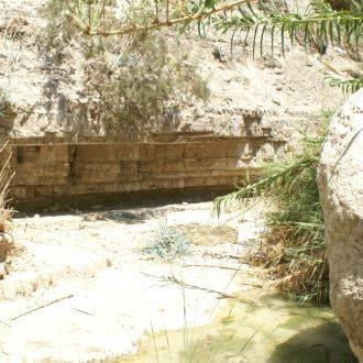
The walkway turns right after 350 meters, and becomes a hanging wooden deck that leads to the observation deck overlooking the lower pool and its waterfall. This is the place to enjoy the beauty of the oasis, which is mentioned in the Song of Songs, 1:14: “My beloved is to me a cluster of henna blossoms from the vineyards of En Gedi.”
Those who are satisfied with the accessible trail may return the same way. Others can continue another half a kilometer, cross the Nahal David tributary, and continue through the cane tunnel to the Shulamit Waterfall. Return to the exit point along the dry trail from the southern bank of the stream.
Returning Its Former Glory
Travelers who visited Ein Gedi before Israel was established, likened it to a huge green savannah, and in the level below the springs and ravines, an enormous tangle of vegetation overgrew. The spring at Ein Gedi formed a strong stream, and the clergyman and naturalist Henry Baker described it as a thin silver thread pouring its waters into the sea of high waterfalls. In the 1950s, the water was diverted from the spring for the use of Kibbutz Ein Gedi. Now, after more than 50 years, the water has been returned to the spring, and the NPA is restoring the unique vegetation on the spring slope and in areas that were cultivated for agriculture.
Along the accessible path, one can see several reintroduced species. One example of a plant that had disappeared and was reintroduced to the reserve is the retama caper – a dense, thorny bush that can reach a height of 4 meters. After the rains, young shoots of plain, narrow leaves grow, with thorns at their tips. They lose their leaves a short time after blooming. The branches have short thorns. The beautiful flowers are red and relatively small in comparison with other capers, and bloom mainly between March and April. You may, however, see a few flowers throughout most of the year. The retama caper could be found and collected during the years before the state was founded in Nahal Hayon and around the Dead Sea, but it became extinct in Israel. The plant grows freely from northwest Africa to the Rajasthan region in India, and a small population grows in Jordan’s Callirrhoe Springs. The NPA has managed to grow the plant from seeds they brought from there, and now the retama caper is once again gracing the slopes of Ein Gedi.
Other trees and shrubs along the accessible path include Maerua crassifolia, cordia, Grewia villosa, Salvadora persica, and milk broom. Other trees include Egyptian balsam, jujube, and different kinds of acacias.
Ein Gedi Antiquities National Park
Another accessible site worth a visit is the Ein Gedi Antiquities National Park, especially the very impressive ancient synagogue. An access road leads from the Nahal David parking area to the entrance to the entrance to Nahal Arugot. The synagogue is to the left of the road, under a tent-like cover.
The ancient synagogue was active during the Mishne and Talmudic period (4-6 centuries AD). The fascinating and colorful mosaic floor boasts geometric patterns, figures of birds and menorahs. Two inscriptions were found in the entry hall before the synagogue hall, including a list of the names of the Patriarchs and elders since creation from Adam to Japheth (Yafit in the mosaic), a list of zodiac signs and months, an inscription swearing the reader to keep the secret of the community, and a dedication. The mosaics show serious attempts to avoid depicting human images, unlike many other synagogues in the north from that period.
The warning inscription in Aramaic is particularly interesting, and says that “ Anyone causing a controversy between a man and his friend, or whoever slanders his friend before the Gentiles, or whoever steals the property of his friend, or whoever reveals the secret of the town to the Gentiles – He whose eyes range through the whole earth and who sees hidden things, He will set His face on that man and on his seed and will uproot him from under the heavens, And all the people said- Amen and Amen Selah.” It appears that the “secret of the town” was the production process for persimmon perfume production, which was invaluable.
The Snir Stream is one of the Jordan River’s tributaries, and it sustains the mature forest along its banks and the rare vegetation associated with wetland habitats. The NPA has made the park accessible and offers everyone the opportunity to enjoy the world of nature and the rare view of the Hula Valley’s streams.
Main Points of Interest
The flowing stream and woods along the banks
Picnic area
Wading pool
Pool for rare aquatic plants
Observations Points
The bird observatory at the Tapline reservoir
Observation point of the Snir Stream
The National Parks Authority has made a wading pool for visitors to enjoy. The NPA does a great deal of preservation and maintenance work here: It has formed a pool that serves as a refuge for the rare aquatic plants that were once typical of the Hula Valley, such as yellow water-lilies and dwarf water clover (Marsilea minuta). It has renewed and restored the channel system that diverted the waters of the Dan Stream to the Snir Stream. It has built crossings for otters – rare mammals in Israel – underneath road bridges, and it maintains the fern population, preventing invasive plants from restricting the growth of the rare large horsetail ferns. The NPA also monitors other invasive plants that could dominate the reserve area, mainly after fires (the reserve is vulnerable to fires, due to the many tourists and the close proximity to the Lebanese border.)
How to Get There
Drive from the Metsudot Junction in Kiryat Shmona, in the direction of Mount Hermon (Highway 99). Turn north after 4.5 km at the Hagoshrim Junction and follow the signs to the reserve parking area.
Background
The Snir Stream flows in the north of the Hula Valley to the foot of Mount Hermon. It is 60 km long, mostly within Lebanon, and it is the longest of the Jordan’s tributaries. The stream begins by the town of Hatsbaya, hence the Arab name of the river – the Hatsbani. The Hebrew Name, Snir, is one of the names for Mount Hermon. Other, stronger springs are the Wazani springs at the foot of the village Ghajar. In the summer, the farmers in Lebanon draw water from the Hatsbani springs, but most of the spring water from Wazani flows to Israel, and today, water is also diverted to the Snir Stream from the Dan Stream. The NPA has restored part of the Nokhila channel and restored the link between Nokhila Valley springs and the Dan Stream.
The road from Damascus to the Lebanese coast passed by the Snir Stream between Mount Hermon and the Hula swamps. The Ghajar bridge over it served as a landmark determining the border between the British Mandate in Israel and the French Mandate in Syria and Lebanon.
Flora and Fauna
Riverside forest grows along the banks of the stream, including oriental plane trees and brook willows, alongside wetland vegetation such as common reed, common giant reed (Spanish cane), purple loosestrife, pale persicaria and watercress. Rare plant species that grow around the Snir Stream include horsetail fern, Stachys spectabilis, and milk broom, which reaches its distribution limit in the south with the Snir Stream.
Growing further away from the water, we have the Mount Tabor oak, interspersed with jujube. These trees create a kind of “forest park” with large spaces between the trees, thus allowing an abundance of colorful seasonal flowers to bloom here in the winter and spring.
The nature reserve’s wildlife includes the otter, a small predator of the Mustelidae family that is in danger of extinction. The otter feeds mainly on fish, and in order to improve their chances of survival, the NPA has made “otter crossings” under the bridges of roads in the vicinity of the reserve, allowing the otters to move between the different sections of the stream, even when the current is very strong. Other noteworthy animals in the reserve include wild boar, porcupines, mongooses and badgers. The Tapline reservoir offers a winter home for many water birds, which nest in the Tapline’s walls in the quieter parts of the reserve. Many invertebrates also live in the reserve, including river crabs, dragonflies, damselflies, primitive crustaceans and water insects. Bathing for visitors in the reserve’s waters harms the wildlife’s activities and as such is permitted only in the wading pool.
The Trail
The Accessible Trail
Trail type: A circular trail that takes about half an hour to complete (not including time splashing in the wading pool).
From the parking area, the trail follows along a channel with aquatic plants that bloom in the summer. The trail crosses one of the Dan Stream tributaries and goes down to the wading pool and its waterfall. It is a great place to freshen up with a cold shower in the summer. Nearby, there is another pool where rare yellow water-lilies grow. The trail arrives at a special observation point that looks over the Snir Stream in all its glory. From here, the trail returns to the wading pool and to the exit point.
Other Trails in the Reserve:
The Mid-Level Trail
Trail type: a circular trail suitable for families that takes about half an hour to complete. The trail includes climbing rock stairs and boulders and hikers cannot avoid getting their feet wet.
From the parking area, walk to the wading pool, as described for the accessible trail. From the pool, follow the signs to the stream. Stairs lead to the intersection between the northern Dan-Snir channel and the Snir Stream. The temperature of the water in the Dan channel in the summer is much lower than that of the Snir Stream.
Parts of the trail along the riverbank are shaded by riverbank vegetation, oriental plane trees and white willow. The trail passes several waterfalls that feed the Snir Stream. After ten minutes, climb left up the stairs and continue along the trail to the exit point.
The Long Trail
Follow the mid-level trail, but instead of climbing the stairs to return to the parking area, continue downstream along the Israel National Trail, until you reach the ledge built of travertine (“the Cascade”). This is a good place to rest and enjoy watching the flowing water. The trail continues along the water shaded by riverside trees, until the end of the trail. From here, you can return to the Snir Stream parking area (about 15 minutes).
New: The Bird Observatory and the Tapline Reservoir
The walk to the reservoir takes about fifteen minutes (the path is not accessible).
Near the Nokhila channel, which leads from Ein Bared north of Tel Dan, the Tapline pipeline runs. This is the Trans Arabian Pipeline that carried oil from the oil fields of Saudi Arabia to the port of Sidon in Lebanon. The pipeline goes through the Golan Heights. In 1969, there was an explosion on the pipeline, and crude oil leaked into the Dan Stream and from there to the Jordan River. Following this act of sabotage, safety measures were taken: The waters of Ein Bared were diverted from the Dan Stream to the Snir Stream, and the reservoir was excavated. The reservoir makes it possible to divert the oil and prevent the contamination of the Jordan River tributaries. The reservoir attracts many water birds such as mallards, coots, teals, little grebes, ibises, herons, storks and more. These can be watched from the hidden observatory constructed for the convenience of visitors.
About a ten-minute walk from the observatory, there is an observation point overlooking the spectacular view of the Snir River, Mount Hermon, the Golan Heights, and the hills of southern Lebanon and the Galilee.
- Type
- Hiking
- Region
- Dead Sea
- Length
- Accessible path: 400 meters. To Shulamit waterfall and back: 1.7 km
- Duration
- One to two hours
- Recommended season
- Spring, Summer, Autumn, Winter
- Starting point
- Ein Gedi (map)
- Ending point
- Nahal David (map)
- Special equipment
- Walking shoes, water, hat
- Precautions
- Do not stray from the marked path, be sure to drink water. May not feed the wildlife, pets are not allowed (the entrance has cages for dogs)
- Parking
- Parking
- Accessibility
- Accessible
- Circular
- Circular
- Drinkable water
- Drinkable water
- Bathing water
- Bathing water
- Suitable for children
- Suitable for children
- Picnic suitable
- Picnic suitable
- Phone
- +972-8-6584285
- Fax
- +972-8-6520228
Similar trails
Spring Water For The Ein Bokek Oasis
Nearby attractions