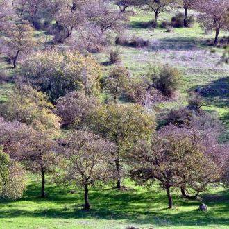
The Beit Keshet Single Track invites us to enjoy a sense of being abroad. It offers a challenging and enjoyable excursion amid green hills and valleys enhanced by wonderful blooms in winter and spring. Mount Tabor’s distinctive profile dominates the view across the open spaces, while in the woodlands pines and oak trees lend a dreamlike atmosphere of mystery.
How to get here:
From Route no. 65, between Kfar Tavor and Golani Junction, turn off towards Kibbutz Beit Keshet. After about 1,200 meters, between a downhill and an uphill stretch of the road, turn to the right in the direction of the Beit Keshet Scenic Trail and leave your vehicle in the parking lot on the right.
Those of you who prefer to leave your car in a more populated area can continue on into Kibbutz Beit Keshet, turn right towards the Radio Kol Rega parking lot, park there and cycle back to the starting point of the trail.
Description of the route
The Beit Keshet trail was the first KKL-JNF single track cycle path anywhere in northern Israel. Today, although scores of well laid out single tracks provided by KKL-JNF now cover hundreds of kilometers throughout the region, the Beit Keshet route retains its charm. Indeed, it still offers a fascinating and challenging ride through flower-carpeted landscapes largely unparalleled anywhere else in Israel.
The route provides an enjoyable experience at all seasons of the year, but we particularly recommend riding it in winter and spring when the hills are covered in flowers and fresh greenery and we cycle along a narrow brown strip between carpets of green studded with anemones, cyclamen, orchids, irises and yellow asphodel (Asphodeline lutea).
All along the way, as we cycle through valleys of fields and orchards, the view is dominated by the rounded peak of Mount Tabor; other peaks are visible in the distance.
The route is about 22 kilometers in length, around 12 kilometers of which is single track. There is a cumulative elevation gain of 500 meters; ascents are of moderate difficulty.
The single track is one way – anticlockwise – and the route is indicated by black painted teardrops showing a cyclist against a yellow background, which have been painted on rocks. The point of the drop shows the direction of travel.
We do not recommend riding the single track after rain has fallen. Apart from the fact that the resulting mud will stick to the wheels and make for heavy going, the track itself may suffer damage.
A word of caution: The trail crosses the asphalt-surfaced scenic route five times, and cars are liable to appear suddenly at high speed. Please take care to come to a full stop and ensure that the road is safely clear before crossing.