Derech Burma - Yitzhak Rabin Park
Hiking
The Route:
During the battles in the War of Independence, Jerusalem was besieged, the road that ascended from the coastal plain to Jerusalem - Latrun and Ayalon Park - was the main artery, blocked and controlled by Arab forces and the Jordanian Legion.
The fighting forces of the Harel-Palmach Brigade occupied the outposts controlling the road from Sha'ar Hagai to the east, in the Latrun area and Dir Ayub, from Sha'ar Hagai to the west. The Givati and 7th Brigade battled but failed in a number of attempts to conquer, and Latrun remained under Jordanian control. The "Latrun Traffic Jam," was the inability to transfer ammunition and supplies to the city, and there was great concern that Jerusalem would not withstand the siege and fall into the hands of the Jordanian Legion.
Due to this situation, there was an urgent need to find a hidden alternative route that bypassed Latrun.
The sites:
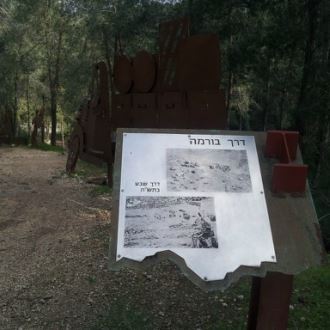
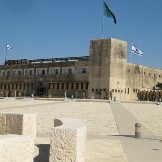
Mitzpe Harel - Begin the trail on the road that is suitable for any vehicle and is marked with the silhouette of soldiers and armored vehicles, which once served as a KKL-JNF lookout for forest fires. The site contains a huge tablet depicting the route of the Burma Road and the battles that took place along it, from there we drive east to the next station, Ein Sussin.
Ein Sussin - The spring was used by the residents of the Arab village of Beit Sussin until it was conquered in May 1948. KKL-JNF rehabilitated the spring and built a parking lot under the shade of large eucalyptus trees. It is worthwhile to stop and have a look at the pumping house and the freight line. In this place, the first two jeeps of the Harel Brigade, which left Bayt Mahsir and Hulda, met each other to see if the road was passable by vehicle.Traveling about one kilometer to the east will bring you to "Ma'ale HaTena".
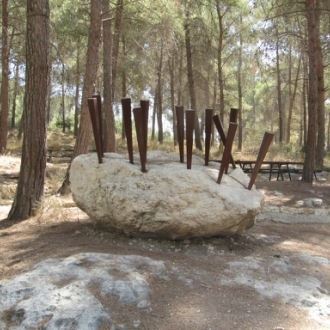
Ma'ale HaTena - the name comes from the fig trees planted on either side of it - in this section, which was very disorganized and impassable by vehicle, supplies were loaded on jeeps, beasts of burden, and volunteer porters went to the other side of the hill, where supplies were loaded onto trucks traveling to Jerusalem. Sculptures of jeeps and trucks made of iron riddle the road. As you travel eastward, you will arrive at a steep slope called Serpentine. It is recommended to walk there on foot and not with the vehicle.
"Serpentine" - a comfortable walk on a dirt road about 700 meters on the Burma Road to the steep end of the slope, where you can see a section of a water pipe that stands as a monument to the "Shiloah" line. This pipeline replaced the main water line to Jerusalem after the Jordanians blew up the pumping station at Latrun, the pipe was placed here quickly and the water flowed back only one day after the explosion.
The next point is an observation point at the Haruv parking lot. The Haruv parking lot observation point looks out over Ha-Masrek Reserve where you can stop for a picnic and rest.
"Ein Hila" - a road junction point - Burma Road with Derech Ayalot, a road that bypassed Latrun and precedes the Burma Road. The main road was headed by the armored vehicles of the Givati Brigade, nicknamed "Ayalot". From this point, a small spring emerges on the side of the road and a picnic area and car park were established. Continue driving according to red markers and arrive at Ein Mesila.
"Ein Mesila" - and the armored car parking lot - a well-shaped spring and an active parking lot where picnic tables, water taps, children's facilities such as swings, slides, sandbox and more.
The next stop is the Sha'ar Hagai Observation Point - known as "Khirbet Hatula". A moderate journey following the signs on a dirt road that is 250 meters long and you'll reach the Sha'ar Hagai Observation Point. The peak of the ridge was captured by Palmach fighters before the first truce in the War of Independence. KKL-JNF began to develop the observatory in 1998, from which there is a spectacular view of Sha'ar Hagai, there is a signpost commemorating the 5th Battalion of the Harel Brigade and a memorial site for fallen soldiers from the United States and Canada.
Anyone who wants to continue the trip on a mountainous section of the Burma Road, on a jeep road that crosses Route 38 to the Machal monument. It is a steep road that leads to Bayt Mahsir and the Burma road ends there as well.
This road segment is suitable only for 4+4 vehicles.
How to get there?
For those coming from the west - Masmiya Junction - Nachshon Junction, drive on Route 3 until Nachshon Junction, turn right onto Route 44 (the Gibora Road) past Moshav Kfar Uriya, about half a kilometer turn left according to signs to Mitzpe Harel (next to the turn is the Mekorot company site). For those coming from the center, Tel Aviv - Jerusalem), drive on Highway 1, at the Latrun interchange, exit right and right again to Route 3, at the Hativa 7 junction, continue driving until Nachshon Junction and turn left onto Route 44, Nachshon Junction - Shimshon Junction, about half a kilometer after the village of Kfar Uriya turn left according to the signs to "Mitzpe Harel" (next to the turn is the Mekorot company site), drive on the narrow road until the "Khan Harel" parking lot.
- Type
- Hiking
- Region
- Judea and Samaria
- Near to
- Jerusalem
- Length
- 3-4 hours or more
- Duration
- About 16 km
- Recommended season
- Spring, Summer, Autumn, Winter
- Difficulty level
- Easy
- Starting point
- Metzpe Harel (map)
- Ending point
- Mezpor Sha'ar Hagai (map)
- Special equipment
- Walking shoes, hat, water, sunscreen
- Parking
- Free Parking
- Circular
- Circular
- Drinkable water
- Drinkable water
- Suitable for children
- Suitable for children
- Picnic suitable
- Picnic suitable
Similar trails
Nearby attractions
Nearby restaurants


Aroma Shimshon Junction