A Rare Water System
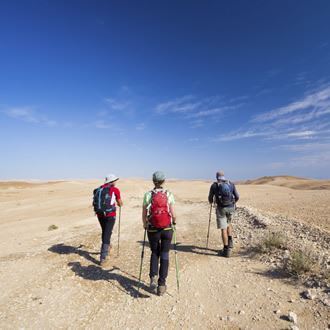
Visit to an archaeological site
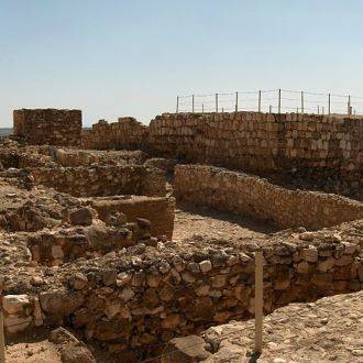
Tel Be’er Sheva provides a rare opportunity to get a glimpse of town planning from the First Temple period. The Israel Nature and Parks Authority has restored ancient buildings with mud bricks, and has recently opened the site’s rare water system to visitors. In 2005, UNESCO added Tel Be'er Sheva to its list of World Heritage sites.
Main points of interest:
The well at the city gate
The altar
The water system
Viewpoint
A lookout tower at the heart of the hill
Israel Nature and Parks Authority activities to improve visitor services and preserve the site
The Authority has allocated a parking area, built toilets and put up illustration signs. The Authority has also restored ancient buildings and built a lookout tower.
How to get here:
From the Be’er Sheva ring road (Route 40), turn east onto Route 60 and immediately south to the Tel Sheva junction. At the Tel Sheva junction, turn right to Tel Sheva.
After around 2 km, turn right into the National Park.
Background
The Tel Be'er Sheva National Park is situated at the top of a small hill to the east of the modern city, at the meeting between the Hebron and Be’er Sheva streams. In the Ancient Israelite period (10th century BC) a fortified administrative city was built here, a government outpost in the southern region.
The city spreads across the whole of the summit of the hill - 12 dunams - and it was built according to a pre-prepared plan: all of the roads run in straight lines; a ring road starts from the entrance gate, surrounding the entire city and running parallel to the walls; the buildings in the outer circle make use of the wall. Two additional roads run from both sides of the square at the gate, and these cross the whole of the city, splitting it into two almost equal sections. A public building stands at the highest point of the hill. There was probably a temple there before this.
Trip route
1. Four-horned altar
The altar stands next to the site’s cash desk. Tel Be’er Sheva’s altar was found in pieces - its stones has become part of the walls of an ancient storehouse. Archaeologists discovered the ornately carved stones and managed to rebuilt the large horned altar.
Burn marks on the stones tell us that sacrifices were indeed performed on the altar. Perhaps one of the Kings of Judea tired of this ritual and dismantled it. The original altar can be found in the Israel Museum in Jerusalem. A model inspired by the original is on display at Tel Be’er Sheva.
2. The front gate and the well
The base of the gate is built from layers of stone with layers of mud bricks on top of these. Next to the city gate, outside the walls, is a 70 m deep well. Digging a well to such a depth in the Ancient Israelite period was indeed an impressive technological feat.
The city’s wall is typical of Israelite cities, and is a ‘cage wall’ - a double wall, where the space in between was used as a built up area. Parts of the wall, which was made out of bricks, have been restored. Inside the city the urban planning is clear: All of the roads in Tel Be’er Sheva lead to the central square, and an advanced drainage system was built beneath the streets to clear away excess water underneath the wall and outside of the city.
3. The main gate and the entrance plaza
Two strong towers protect the main gate, and the entrance plaza spreads out behind the gate. Archaeologists think that this kind of square, which was common in cities in the biblical period, is “the square at the city gate” mentioned in the Bible (II Chronicles 32.6). This was the city’s main square, and was where residents would gather and the market would be held. Tel Be’er Sheva also had a ring road running parallel to wall, which was the end point of the roads which crossed the city from side to side.
4. City buildings
The tour path goes between the city’s buildings. The first building, the ‘palace’, was used by senior officials. The building has an entrance corridor and two paved halls, which were probably used for official events. It also contained living quarters, a kitchen and a store room.
At the western side of the ring road, and ancient pathway has been uncovered, which attests to the fact that the city plan was maintained without change. At the side of the road the ‘Cellar House’ has been uncovered - a buildings whose foundations were dug at a depth of 4 m. Two of the rooms in the building were underground cellars. It might be that the foundations here were especially deep because the building was built on the site of a temple which had been taken down.
The houses in the neighbourhood to the left of the ancient road are incorporated into the wall. They are built uniformly. Each house had three or four rooms: an entrance hall, which was probably used as a yard and a cooking area, and from which stairs led up to the roof; two store rooms and a colonnade between them (farm animals were probably kept in one of these rooms); and a back room for sleeping. This room was also part of the wall.
5. Lookout tower
The lookout tower looks over the whole of the hill and onto the Be’er Sheva valley. At the foot of the tower the remnants of a fortress can be seen, which was built in the Roman period and restored in the Early Arab period.
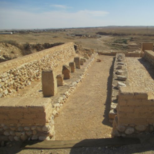
6. The storehouses
The tour path goes past three large buildings, which cover around 600 m2. Two colonnades split each building into three long sections. The middle section was a corridor for bring supplies by donkey, and the sections to the right and left were storage areas. Hundreds of pieces of pottery have been found in these buildings. The Tel Be’er Sheva altar was restored from stones found in the northern wall of these storehouses.
7. Water system
The highlight of the tour of the site is the 10th century BC water system. A huge square shaft with stone-lined sides, descends to a depth of 15 m. As the shaft goes down, the walls close in, in order to maintain stability.
Although it is very deep, the shaft does not reach the ground water. Tel Be’er Sheva’s water system consists of a large reservoir for collecting water when the Hebron stream floods. Although 3000 years ago the Hebron stream passage did run closer to the hill, even then it took considerable ingenuity and high-level engineering capabilities to divert the water to the reservoir.
The tour of the reservoir is very impressive. It has a capacity of 600 m3, and the walls remain intact with their original plaster. When the reservoir was excavated, seven layers of plaster were discovered, five of which were from the Iron Age. In the Iron Age there was a tectonic shift, following which they strengthened the reservoir's roof with supporting walls. On the supporting wall on the inside of the reservoir, the craftsmanship of the plaster work can be seen from one of the Iron Age layers. The plasterers created plaster ‘pancakes’ and stuck them to the sides of the reservoir. After this they spread out the layers using their hands - as we can see from handprints in the plaster.
The two upper layers of the plaster were added at a later time, perhaps during the Hellenistic period. At this time the flooding of the Hebron stream ceased to be the source of the water, and many parts of the reservoir fell out of use. Instead, surface runoff water was collected from the area of the hill.
Next to the exit are the remains of a part of the water canal which brought the Hebron stream flood water to the reservoir.
- Type
- Hiking
- Region
- South
- Near to
- Beer sheva
- Length
- 800 Meters
- Duration
- 1 Hour
- Recommended season
- Spring, Summer, Autumn, Winter
- Starting point
- Tel Be’er Sheva National Park (map)
- Ending point
- Tel Be’er Sheva National Park (map)
- Special equipment
- Shoes, hat
- Precautions
- Do not climb old buildings
- Parking
- Parking
- Circular
- Circular
- Drinkable water
- Drinkable water
- Suitable for children
- Suitable for children
- Picnic suitable
- Picnic suitable
- Phone
- +972-8-6467286
Similar trails
Nearby attractions


Goodman - Acting School of the Negev

Yes Planet - Beer Sheva
Nearby restaurants


Burgeranch B7