A trip to the heart of the country
Drive and short hikes
Neot Kedumim
Access: Neot Kedumim Park is located on the Ben Shemen - Modiin road. The entrance to the park is 4 km from the Ben Shemen interchange (Route 443, between kilometers 8-9).
The Neot Kedumim Park is defined as the National Park of Israeli nature. The park is managed by a non-profit organization. The founders of the park were Dr. Ephraim and Hana Ha-Reuveni, who immigrated to Israel at the beginning of the 20th century and sought to integrate the knowledge of the country's plants into the study of the Bible. Their son, Noga Ha-Reuveni, fulfilled the vision.
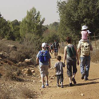
The park covers 625 acres and represents the nature and agriculture of the country according to the descriptions of the Bible, the Mishna and the Talmud. There are marked hiking trails between planted gardens and wild areas. Along the walking paths you will find pools of water and restored agricultural equipment.
At the visitor center at the entrance to the park, you will receives a booklet containing a map of the tour routes. The routes are circular, leaving the visitor center and returning to it. At the visitor center there is a cafeteria and a shop for professional literature in the field of hiking.
The trail signs and the hundreds of permanent information signs leave no room for errors regarding orientation. Garden areas also have toilets, water drinking fountains, picnic tables and shaded areas. You should reserve three or four hours for the gardens.
Hiking routes in Neot Kedumim
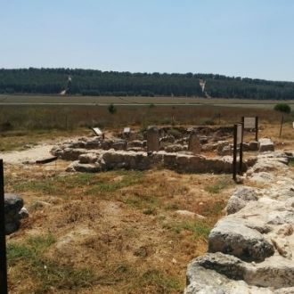
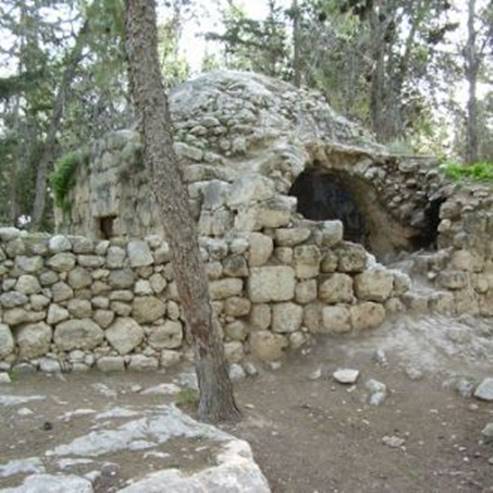
Trail A (marked with white): length: 2.5km. In addition to the explanations of the natural vegetation there are archeological finds that were found and reconstructed, including a water cistern, an olive press and a winepress from the Talmudic period, remains of a residential quarter dating to the Second Temple period and two water pools. In one special plot there were Lebanese cedar trees planted. The trail is paved and accessible.
Trail B (marked with blue): length: about 2.5 km. The track passes through the pool of Sycamore trees, and descends to the area that is representative of the HaSharon Forest. After passing Solomon's Pools, which brings with it the views of the Song of Songs, the trail ascends between flower beds to ancient mosaics – the mosaic floor shows the months of the year on the Hebrew calendar. The trail is paved and accessible.
Trail C (marked with green): length: about 3 km. This trail focuses on the trees of the forest, the seven species, and the four species, which are blesses on Sukkot. An interesting attraction is the antique wheel for pumping water, which is installed in the palm pool.
Trail D (marked with yellow): The length of the route is about 5 km, and the long route is parallel to trail C in certain sections, but it is longer because it descends to Nachal Netof. The trail offers a beautiful vantage point of the views in the area. Along the trail there are a variety of reconstructed Sukkahs, a flour mill and a stone watchtower, reminiscent of the vineyard of the Book of Isaiah. Part of the route is paved and accessible, but some of which passes through natural slopes. This trail is not suitable for people with limited mobility.
Services for people with limited mobility
Three of the four trails in the park offer seven kilometers of accessible trails. The paving of the accessible paths is an operation carried out by the Ministry of Tourism and the Kahanov Foundation. It is better to have someone with you that does not have limited mobility because some of the slopes may be too steep for some people (in the event of a problem, please call the visitor center and ask for assistance).
Hours of operation: Sunday-Thursday, 8:30-16:00, Friday and Holiday eve 8:30-13:00 – Tel – 08-9770777
Arazim (Cedar) Valley in Jerusalem Park
Access: from Neot Kidumim return to the Ben Shemen Interchange and continue on Highway 1 to Jerusalem. After approximately 2.5km after the Harel Interchange you exit towards the entrance of Moshav Beit Zayit and turn left immediately. Travel 450 meters parallel to Highway 1 towards Mevaseret Zion. Pass under the bridge on Highway 1 and turn right immediately on the paved road, following the signs to the September 11th Memorial. After 1 kilometer you will arrive at an old two-story building. The sign at the site announces that you have reached the Einot Telem National Park, located in the heart of the Arazim Valley.
The Arazim Valley is the result of Nachal Sorek, which runs here between the mountains of Jerusalem. In the past, there was huge kidney shaped portion planned to be cut down in the valley. The "Safdie Plan" for the development of Jerusalem included the Arazim Valley at the end of the developed area of Jerusalem. A vigorous environmental struggle by the nature organizations in Israel led to the postponement of the plan and the preservation of the valley as an open area.
The Arazim Valley is one of the pillars of the Jerusalem Metropolitan Park. The park will cover 1250 acres and will surround the entire city of Jerusalem with a green belt. The park will maintain a view of traditional farming terraces and small mountain springs, planted forests and natural groves. It will have pedestrian and bicycle trails, outdoor recreation parks and sports facilities.
The Jerusalem Metropolitan Park is a joint initiative of the Jerusalem Municipality, the Jerusalem Development Authority, KKL-JNF, the Nature and Parks Authority and other bodies.
Our route will visit the Arazim Valley at two sites: Einot Telem National Park and the September 11th Monument
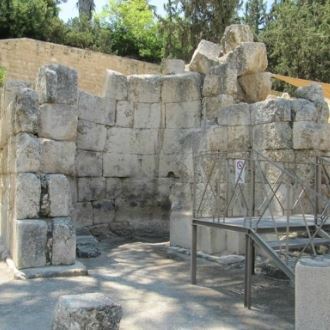
Einot Telem National Park - Three small springs appear from a cliff in the rock. The Israel Nature and Parks Authority, which restored the ancient agricultural terraces, and during excavations conducted at the site, revealed remains of buildings from the Byzantine and Crusader periods.
The spring water is collected into small pools and in the past they drained into a large storage pool, which lies on the north side of the two-story old building.
In 1906, Dov Klimker and Aharon Eisenberg, from Rehovot, purchased a 57 acre plot of land. They hoped to operate a factory for soap and oil, but had to leave. In 1922 five Jewish families settled there. They lived in a building and in tents next to it. Later, additional buildings were built there. The small settlement, Beit Telma, was also called "Valley of the Cedars", after the beautiful trees that grew around the springs.
The settlement was abandoned in the events of 1929. Another settlement attempt was made in 1934, but it did not succeed either. The building inside the compound is a pump house built by the British (no entrance to building! danger of collapse!).
After wandering among the tiny springs and enjoying the view, you will return to your vehicle, drive on the paved road and continue to drive up towards Nachal Sorek. At the first intersection turn left, according to the signage towards the September 11th monument.
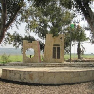
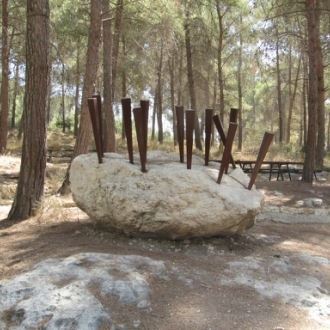
The 9/11 Memorial - The monument stands in the heart of a KKL planted forest, and in the heart of a round Stone Square, the artist Eliezer Weishoff placed a large bronze statue, nine meters high. The statue has the flag of the United States and its top resembles fire towards the skies. Through a glass window at the base of the statue there is a piece of steel from one of the Twin Towers.
KKL-JNF erected the impressive monument with thanks to the donation of the Bronka Stawski Rabin Foundation to the Blanc family of New York.
Sataf
How to Get There? Returning on the road down on which we came to Highway 1, we drive toward Tel Aviv about 2.5km, until the Harel interchange. Continue roundabout at the intersection with Highway 395. From the roundabout, follow the signs pointing to Sataf.
We will stop for a moment in the upper parking lot and receive a map of the Sataf routes (there are also toilets). Then we will return to the car and drive down the paved road another 1.5 km to the central parking lot. From here we will continue on a short walking path.
Sataf is a charming corner where KKL-JNF has restored about 250 acres of traditional agriculture. Most of which is cultivated on stone terraces, as they used to cultivate the land in the Jerusalem hills for thousands of years. The waters of two springs, Ein Sataf and Ein Bikura, are collected into ancient pools and transferred to irrigate plots.
There are five different trails in Sataf. On this trail we will focus on the "Trees of the Land of Israel Orchard" area (marked with blue). The Orchard preserves 19 species of fruit trees, which include various types. Five of them are the "Seven Species" trees, which are joined by apricot, apple, pear, almond and plum, quince - members of the Rosaceae family. There are also carob trees, pistachio trees, walnut trees and mulberry trees. The orchard of the Trees of the Land of Israel is a "gene bank" of the fruit trees of the Land of Israel.
The trail
Length of the trail: about 1.5 km.
Walking time: approx. 1 hour.
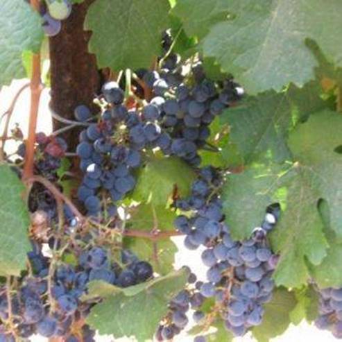
From the main parking lot, the path marked with blue goes west and immediately reaches the terraces where grapes are grown. In this section of the vineyard there are about 35 species of vine. The path continues to a fig orchard, where no fewer than 90 species of fig trees have been collected. Some of these species seem to have disappeared from the country and the Sataf is the only place where they now grow. This project of conservation of fruit trees was carried out in cooperation with the Association for the Recognition of the Fruits of the Jewish People, and the variety of species is of great importance, as it is possible that in the future we will need the genes of the traditional varieties to enhance today's varieties.
The trail passes along an ancient path. Above the path is a watch tower. This is a stone structure that was used by the peasants during the burning seasons when collecting the crops. Our trail curves to the left and passes through the olive grove of Sataf, which preserves about 30 varieties of olive. At its end is an ancient wine press hewn in the bedrock. In the winepress grapes were crushed by foot to extract the must, fermented into wine.
Near the winepress is a common oak grove with one large and impressive tree. The oaks grow within the remains of buildings from the Byzantine period. There may have been a church and a storage pool in the past. According to Muslim tradition, here was the tomb of a saint named Sheikh Obeid.
The last section of the trail overlooks the Monastery of John in the desert and ends with Ein Sataf. After enjoying the spring and the large pool next to it, climb about 200 meters on the dirt road leading to the central parking lot, where your car is parked.
For hiking enthusiasts. The Jerusalem Trail
The "Jerusalem Trail" passes through the Arazim Valley and the Sataf. This is a circular pedestrian path that runs through the important sites in the city and the surrounding mountains. In the Sataf area, the Jerusalem Trail merges with the "Israel Trail" and provides an opportunity for pedestrians to tour the capital.
The Jerusalem Trail is about 38 kilometers long. The path is marked along its entire length along the usual trail markings, but with unique colors: two blue stripes with a golden stripe in the middle. In some of the markers the symbol of the lion of Jerusalem was also added. In order to see all of the sites along the path, it is necessary to devote at least four days of hiking.
- Type
- Hiking
- Region
- Jerusalem Area
- Near to
- Lod
- Length
- 60 KM.
- Duration
- Full day
- Recommended season
- Spring
- Difficulty level
- Easy
- Starting point
- Ne'ot Kedumim (map)
- Ending point
- Ha' Sataf (map)
- Special equipment
- Hat and water
- Parking
- Free Parking
- Accessibility
- Accessible
- Drinkable water
- Drinkable water
- Bathing water
- Bathing water
- Suitable for children
- Suitable for children
- Picnic suitable
- Picnic suitable
- Phone
- +972-8-9770777
Similar trails
Nearby attractions
Neot Kedumim Park


Nearby restaurants