From Ein Zivan Campground To Bab Al-Hawa
A one-way track, Climbing steep in mountain top
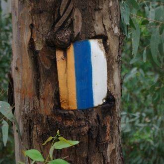
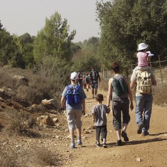
The Israel Nature and Parks Authority participates in the marking of the Golan Trail. This segment of the trail is elevated 1,000 meters above sea level. The steep path leading to the top of Mount Bental requires physical exertion, but the hikers are rewarded by reaching the Bental reservoir and the Bab al-Hawa ancient site.
Main points of interest
Monument to the fallen of the 134 reconnaissance battalion
Volcanic activity in the Golan Heights
Aleppo-oak woodland
Winter puddle in Bab al-Hawa
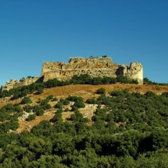
Remains of an Iturean site at Bab al-Hawa
Scenic lookout
A magnificent vista of the Golan Heights and the Bashan from the top of Mount Bental.
What Israel Nature and Parks Authority does to better serve the visitors
The Israel Nature and Parks Authority participates in the marking of the Golan Trail (white-blue-green).
Getting to Ein Zivan campground
Highway 91. The entrance to the Ein Zivan campground is across from that to kibbutz Ein Zivan.
Getting to Bab al-Hawa
Highway 959, next to the 16-km mark. The entrance is 1.1 km east of the Bental junction.
Background
The marked Golan Trail stretches along the full 120-km length of the Golan Heights, from Mount Hermon to the southern end of the plateau. Its designers divided the trail into 15 segments, each suitable for both regular hikers and entire families. Those up for the challenge can cover two segments a day, and finish the whole trail within a week. Lately signs have been added to points where the trail crosses the highways of the Golan. The trail described here is segment no. 5 of the Golan Trail.
The trail route
1. Ein Zivan campground
The Ein Zivan campground is situated next to natural woodland, consisting mainly of Aleppo and Tabor oak trees, as well as planted tree varieties. The campground also houses the monument to the fallen of the 134 reconnaissance battalion. This is a modest monument, displaying an old M4 Sherman tank, an APC turret, and a Syrian 122 mm artillery piece.
2. Ein Zivan woodland
The Golan Trail begins at the campground, heading west along highway 91, and crossing it west of kibbutz Ein Zivan. The trail first enters the thick woodland of Aleppo and Palestine oaks, and soon leaves it, reaching a basalt plateau covered with terraces. Many Aleppo oaks use piles of local rocks as support. This is a deciduous tree, growing at elevations greater than 1,000 meters above sea level. The oaks are interspersed with Spanish broom bushes.
The plateau is large, and is used as pasture. On the right there is Mount Avital (Tall Abu an Nada), 1,204-meters high. The top of the mountain is home to an active IDF outpost, and as such the access to it is blocked to visitors. The mountain is named after Sheikh Abu Nada, who is buried at its top. Abu Nada (Av Tal in Hebrew – “source of dew”) got its name from the fog that often hides the mountain during mornings, as well as from the ability of the late Sheikh to bring about rain.
The Golan Trail passes next to an apple orchard, reaching a roundabout close to kibbutz Merom Golan. Cross the road, and keep going north for about a kilometer along the Merom Golan highway. The trail meets the highway at a point were a paved road ascends to Mount Bental.
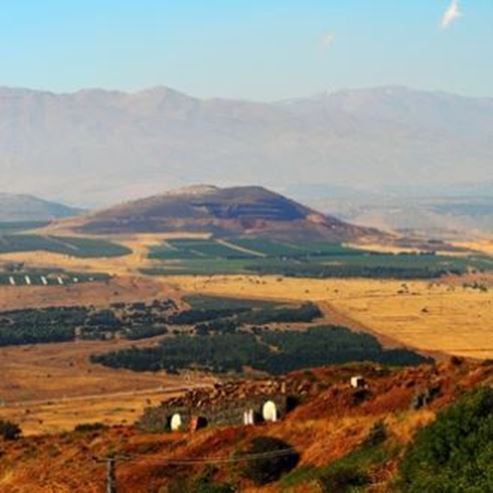
3. Mount Bental
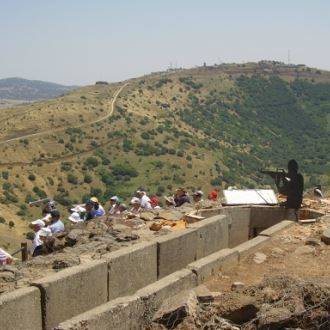
Instead of driving to the top of the mountain, hikers climb the steep 150-meters path following the paved road. The top of the mountain is home to an unmanned IDF outpost and to the famous Coffee Anan coffeehouse.
Mount Bental rises to 1,165 meters above sea level west of Quneitra valley. The two mountains, Bental and Avital, are part of the vent of the same volcano. An audio information station at the site provides explanations about the beautiful scenery in front of the visitors. To the east are the Quneitra valley and the basalt plateaus of Syria, as well as Mount Hermon, Southern Lebanon, the Galilee mountains, and the Golan Heights. Quneitra is worth a closer look: the town was conquered by Israel in the Six-Day War and abandoned by its residents as a result, but was transferred back to Syria as part of the 1974 disengagement agreement. The Syrians built a new town next to the ruins of the old one, and called it Madinat al-Baath; it can now be seen from here just east of the old Quneitra.
The iron sculptures next to the coffee house are by Joop de Jong, member of the kibbutz Merom Golan.
4. The trail to Quneitra valley
The Golan Trail descends to the western end of the large Quneitra valley, which extends into the Syrian territory. This fertile valley is covered with orchards, vineyards and crop fields. In excavations conducted in the valley, archaeologist Naama Goren-Inbar found a prehistoric site with a large collection of animal bones – among them those of a rhinoceros, large wild bovines, horses, a lion, a tortoise, a red deer, a gazelle, and a wolf. Some of the bones bore marks of incisions made by humans some 54,000 years earlier. During that period the Quneitra valley was covered by a large lake, where animals came to drink, and where humans hunted them.
A steep 1-km long path descends from the northern slope of the mountain. Along the way you can see remains of a natural woodland, including Palestine and Aleppo oak trees, as well as Sicilian sumac and other trees.
Upon reaching the valley, you will see the Bental reservoir, collecting water from rains and streams flowing east. The Golan Trail passes next to the reservoir, crossing highway 959 and descending to Bab al-Hawa (next to the sign marking the entrance to this segment of the trail).
5. Bab al-Hawa
Bab al-Hawa is an interesting site, and is also the final point of this trail segment. We first visit the underground burial cave, the entrance to which is not easily visible from the outside. The cave mouth is located 70 meters west-southwest of the point where the Golan Trail crosses the highway. The cave roof, level with the ground above, is made of stone plates in what is known as the Hurrian construction style. Each wall in the cave contains eight burial niches, placed in two rows.
After about 100 meters to the west we reach the Baron (Bab al-Hawa) pool – a nature reserve protecting a winter puddle containing some unique flora and fauna. Among those are five out of the seven amphibian species known in Israel: the eastern spadefoot, the southern banded newt, the European green toad, the marsh frog, and the tree frog.
This winter puddle fills a natural indentation in the ground, and at its peak extends to 0.12 km². During the Byzantine period residents of Bab al-Hawa divided the pool with a dam, and used its southern part as a water reservoir. Therefore, the breeding site of the newt and co. is not only the work of nature, but is also the result of human efforts of the ancient Bab al-Hawa residents – namely the Itureans.
The trail passes among the Iturean houses, reaching a large sign informing us of the end of this segment of the Golan Trail.
- Type
- Hiking
- Region
- North
- Near to
- Katzrin
- Length
- 10 Km
- Duration
- 5 Hours
- Recommended season
- Spring, Summer, Autumn, Winter
- Starting point
- Ein Zivan, Golan (map)
- Ending point
- Bab Al-Hawa, Golan (map)
- Special equipment
- Shoes, Hat, Water
- Precautions
- In the summer should bring plenty of water
- Parking
- Parking
- Drinkable water
- Drinkable water
- Picnic suitable
- Picnic suitable
- Phone
- +972-4-6850664
- Fax
- +972-4-6826012
Similar trails


Accessible route between charming rivulets

Nearby attractions
Nearby restaurants

Meatshos - Katzrin