Bicycle trip to Muhraka
Cycling
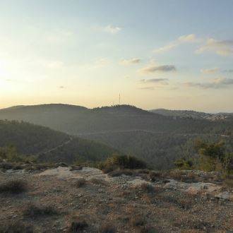
The trail offered here is a route in the upper part of the Carmel between the Muhraka Monastery and Isfiya. The trail passes through an ancient ruin, continues to the village spring on the edge of the Druze village of Isfiya, descends in the upper channel of Nahal Yagur and continues along the Nof Carmel road, which provides spectacular views. The trail is mostly comfortable and is also suitable for families on a shortened 13 km route.
The Carmel has stood alone and green, as if forgotten in the center of the developing country. For thousands of years it has attracted loners and runaways. The prophet Elijah chose it as a hiding place. The Jews fled. After the failure of the Bar Kokhba revolt, monks chose to seclude themselves in monasteries where the Druzes settled there because no one else was there. The Zionist revolution also passed on Mount Carmel, and just before the real estate revolution it was declared a national park, leaving us with a piece of land with clean winter air and smells of green trees and summer shadows, autumn leaves and autumn views, and the constant renewal of spring. It is an asset for all who wish to continue living in our crowded land.
How to get there:Drive on Route 672 to Daliyat al-Carmel. At the third roundabout in Daliyat al-Carmel, turn right after the signs to Muhraka. Park the car next to the monastery.
The trail
[1] 0.00 (northwest): Exit the Muhraka monastery on the road where you arrived. Pedaling towards Daliyat al-Carmel.
1.50 (1.50) right (north): ride on the asphalt road that becomes a gravel road.
1.79 (0.29) left (north): a tin shed and a beautiful Mount Tabor Oak tree. Get on the trail through the fields marked with blue trail markings. The road passes through a common oak forest, under which nothing remains because of intensive grazing.
[2] 2.72 (0.93) straight (north): split. Continue with the blue markers. It is worthwhile to stray right here with the green trail marking to Horbat 'Ali a-Din, a settlement from the Roman period that was not excavated but whose remains are clearly visible in the area.
3.50 (0.78) left (northwest): curve in the path. Continue with the blue markers.
4.60 (1.10) straight (north): the outskirts of the Druze settlement of Isfiya. The dirt path turns into a road.
[3] 5.28 (0.68) straight (north): split. Continue up the road with the blue markers.
Short track: At this point you can shorten the route by turning right and down to the road that turns to a path about 600 meters to the Nof HaCarmel. The shortened track will connect to the long track at point [6] from kilometer 11.68 onwards.
5.67 (0.39) right (north): a junction near a Israel Post distribution center. Pedaling on the steep incline to the roundabout.
5.80 (0.13) straight (northeast): A roundabout that connects six roads. Choose the moderate descent towards the orange-pink painted house.
6.05 (0.25) straight (north): descend on a steep dirt road along a row of cypresses. The road down turns west and descends into the ravine under a technical riding section with many stones.
[4] 6.40 (0.35) left (west): split. Ride 50 meters to Ein El Balad, the spring of the village of Isfiya. Here you can see salamanders between November and January. Return to the trail and continue along a technical slope (northwest) along the upper part of the Yagur stream, following the red markings.
7.30 (0.90) right (northeast): Meeting with Derech Nof Carmel. Ascend upon the good gravel road after the green markings.
[5] 8.30 (1.00) left (south-east): Paths split next to parking lot. Here there is a toilet and a water fountain. Continue along the scenic Carmel road with the green markings.
11.20 (2.90) left (east): A sharp curve in the path over Nahal Hasifa. The trail markings turns from green to black. Continue along the Nof HaCarmel with the black markings. Along the way spectacular views to the north, the Lower and Upper Galilee, the Jezreel Valley and the Kishon.
[6] 11.68 (0.48) straight (south-east): Continue on the road with the black trail markings.
Short track: Here connects the short path that started at point [3] at kilometer 5.28.
[7] 16.00 (4.32) left (east): A fork in the trails. Continue along the Nof HaCarmel with the black markings.
18.65 (2.65) straight (south-west): split. The road becomes an asphalt road. Continue up to Muhraka.
18.95 (0.30) left (south): Junction. Continue to ascend.
[1] 19.60 (0.65): End at the Muhraka Monastery.
- Type
- Cycling
- Region
- North
- Near to
- Haifa
- Length
- 20 Km
- Duration
- 2-4 Hours
- Areas of interest
- Nature , religions and folklore
- Recommended season
- Spring, Summer, Winter
- Difficulty level
- Medium
- Starting point
- Carmel Horn Monastery ( Muhraka ) (map)
- Ending point
- At the starting point (map)
- Map
- No. 4, Carmel
- Parking
- Parking
- Accessibility
- Accessible
- Circular
- Circular
- Drinkable water
- Drinkable water
- Picnic suitable
- Picnic suitable
Similar trails