A track on Mount Ethan
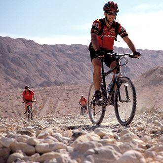
Cycling
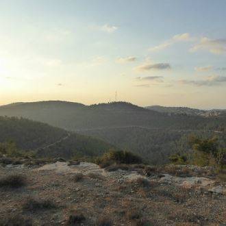
A nice family hiking trail in the heart of the Judean Mountains. The trail crossed Mount Eitan and through a comfortable path, which offers riders a complete landscape of the Judean Mountains. For riders, this area promises crisp, clean air, smells of pine and moss with beautiful flower blooms. When in bloom, their vivid colors add beauty to this very "Israeli" trail. The trail is suitable for the whole family. Those interested in an extended ride can ascend to the top of Mount Eitan, an effort that will be rewarded by an amazing viewpoint over the entire area (length of extended trail: 11.3km).
How to Get There:Travel on Highway No. 1 and get off at Harel Interchange and turn south according the signage to Tzova and Sataf. After 3km you will arrive at a roundabout, from which you ascend towards Sataf. After 600 meters at the top of the road you will arrive at a big parking lot next to a kiosk at the entrance of Sataf. There you park your vehicles.
The Trail:
0.0 [1] (north): Descend from parking lot to the road.
0.10 (0.10) left (southwest): enter the section marked with "Mount Eitan Nature Trail" signage and follow the arrow markers in red – this comfortable trail covers the mountain.
4.20 (4.10) [2] left (west): there is a junction about 100 meters after the sign marking 4km. At this point ascend to the top of Mount Eitan. The trail returns to this point. You may wait here for the brave riders that have pedaled their way to the top of the mountain.
4.70 (0.50) straight (west): junction. Ascend the mountain.
5.50 (0.80) straight (northwest): junction at the top of the checkpoint. Stay left on the trail that encircles the checkpoint and turn towards the northeast.
6.55 (1.05) right (south): junction. The trail leads westward to the top of Mount Eitan.
7.25 (0.70) [3] return (northeast): Top of Mount Eitan. After resting from the ascent and enjoying the views, return on the same trail from which you came.
7.43 (0.18) right (southeast): junction. Descend.
7.57 (0.14) right (south): junction. Continue downward.
7.85 (0.28) straight (west): junction.
8.15 (0.30) left (northeast): junction. Descend a very steep and difficult section.
7.75 (0.60) left (northeast): T junction at the end of the descent.
7.80 (0.15) [2] left (north): return to the nature trail of Mount Eitan marked with red. Here you rejoin the riders that did not make the journey to the top of the mountain.
10.10 (2.30) left (north): Meeting place with the road leading to Sataf. Ride on the upper road marked with red arrows.
11.30 (1.20) [1]: finish at parking lot next to the kiosk.
On Foot at Sataf
Leave the parking lot where you started and finished the bike tour. The remnants of the buildings around you are the remains of the settlement of Sataf, an Arab village whose residents fled the area in 1948. The abundant springs, orchards and terraces remain the same. In 1949 an attempt was made to settle the site by immigrants from North Africa and with the support of the Lehi paramilitary organization.
Soon the settlement was abandoned. The site has since been renovated and is well maintained by Keren Kayemeth LeIsrael. Ein Sataf is actually a system of tunnels that lead from a hydrothermal vent to a large pool.
On the slope you will see the storage pool, climb one level above it and you will see a small opening in the side of the mountain. Enter through this opening to the source of the vent. From there you can continue crawling (with flashlight) inside the tunnel and exit after ten meters at the storage pool. The function of this pool is to store the water flowing from the hydrothermal vent. From there the water is channeled towards the cultivated plantations.
Sataf Spring continues east to Ein Bikura. Ein Bikura is also a system in which a tunnel leads water from the hydrothermal vent to a storage pool. On the eastern (right) side of the pool you can descend the stairs to the water and then enter the tunnel, which is about 15 meters long. At the end of the tunnel you will see a large rock-hewn cave with channels for draining the dripping water, which drains into the pool.
- Type
- Cycling
- Region
- Jerusalem Area
- Near to
- Jerusalem
- Length
- 7.7 Km
- Duration
- Up to two hours
- Areas of interest
- Archaeology / History , Nature and Landscape
- Recommended season
- Spring, Summer, Winter
- Difficulty level
- Medium
- Starting point
- The Parking on the entrance to the Sataf (map)
- Ending point
- Starting point (map)
- Map
- No. 9, passageway to Jerusalem ( "corridor" )
- Parking
- Parking
- Accessibility
- Accessible
- Circular
- Circular
- Picnic suitable
- Picnic suitable
Similar trails